TerraSolid 软件系列是第一套商业化LiDAR数据处理软件,由总部位于芬兰赫尔辛基的TerraSolid Oy公司开发,安徽墨卡托科技有限公司代理。TerraSolid软件的主要模块是基于Microstation开发的插件系统,运行于Micorstation系统之上,它包括了:TerraMatch、TerraScan、TerraModeler、 TerraPhoto、TerraSurvey、TerraPhoto Viewer、TerraScan Viewer、TerraPipe、TerraSlave、TerraPipeNet等模块。
TerraSolid软件系列能够快速的载入lidar点云数据,在足够内存支持下(2G),载入3900万个点只需要40多秒。
为了确保您的售后服务质量和自身利益,我们建议中国用户从正规合作伙伴处购买合法的TerraSolid软件产品。
适用性强:
Terrasolid软件支持机载、车载和静态等点云和影像数据的处理,兼容点云格式多样(xyz,txt,bin,ebn,fbi,以及标准格式las),且支持用户自定义点云格式。
生产效率高:
Terrasolid软件具有快速加载海量点云的技术优势,在标准配置的工作站下,载入39000000个点只需要40多秒;可以将点云分幅在项目中进行批量处理,也可以通过TerraSlave模块分配任务,发送任务至其他PC分布式处理。
处理数据灵活:
用户根据实际情况编写算法流程和设置参数,灵活处理不同地形的数据。
功能强大,成果多样:
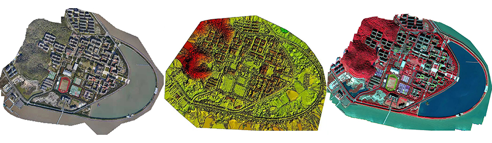
Terrasolid软件不仅支持点云校正,点云分类,4D产品输出,还能进行三维建模,电力巡检,净空分析,坡度视线分析,变化检测,森林统计,体积计算,三维可视化等,应用于各行各业。
Terrasolid Software
Terrasolid is the industry standard software for point clouds and images processing.
Conduct in-depth analysis of your data, build detailed models and vectors, and produce high-quality deliverables at top speed.
Choose a licence tailored to your applications, including a range of packages dedicated to UAV mapping.
Terrasolid is particularly effective for processing data captured with the DJI Zenmuse L1 sensor.
It can be used as a next-step software to DJI Terra, but has significant advantages, including additional processing capabilities and provides a greater suite of features, such as object classification and cleaning.
Terrasolid is suitable for a range of industry applications, including forestry, powerlines, city planning, infrastructure such as roads and railways, mining, and bathymetry.
Purchasing the software through MOKATO has numerous advantages:
We are experts in the UAV and Terrasolid platforms - providing supply and support for each;
Our in-house surveying team has used the Terrasolid workflow for project-based data collection and processing;
Our surveying specialists have produced many LiDAR workflow courses - including point-cloud optimisation and classification in Terrasolid - very useful and helpful for users.
模块功能:
TerraScan模块:
Terrasolid模块是用于处理原始激光数据的多功能应用程序。模块支持对海量点云进行查看、编辑和分类等操作,配置大内存工作站,一次能处理超过4000万点。软件可兼容多种点云格式,支持大多数厂商的仪器。模块里提供的工具可以广泛应用于电力输送、洪水分析、高速公路设计、钻孔勘探、森林普查、城市建模等不同行业领域。
TerraScan
TerraScan is the main application in the Terrasolid Software family for managing and processing all types of point clouds. It offers import and project structuring tools for handling the massive number of points of a laser scanning campaign as well as the corresponding trajectory information. Various classification routines enable the automatic filtering of the point cloud. It is particularly effective for LiDAR data.
TerraModeler模块:
TerraModeler模块是一个多功能的地形建模应用程序。模块可以创建、编辑和处理各类特征模型;支持多源数据的导入和建模,包括激光点云数据、设计图形数据等;提供多样的可视化方案,例如颜色分类表面、边界线、三角格网等。
TerraModeler
Create, edit, and utilise surface models. TerraModeler creates surface models (TINs) from various sources, such as LiDAR points stored in binary files or loaded in TerraScan, XYZ ascii files and graphical design elements. The software offers versatile visualisation options including coloured shaded surfaces, contour lines, grids, coloured triangle nets, elevation texts, slope directions and textured surfaces (in combination with TerraPhoto).
TerraMatch模块:
TerraMatch模块是用于校准和匹配激光数据的应用程序。模块通过对比轨迹数据和重叠的激光条带,将姿态数据的改正值应用到相应的数据中,校正参数完成拼接,以获得最佳的匹配度和准确性。实际的工程数据中可能涉及数据源错误,TerraMatch可以对整个数据进行改正或对每条航线单独进行改正。
TerraMatch
TerraMatch is a sophisticated tool for improving the accuracy and quality of the raw laser point cloud. It compares laser data from overlapping flight or drive paths and calculates correction values for the misalignment angles as well as xyz location errors.
TerraPhoto模块:
TerraPhoto模块广泛应用于根据航空影像产生正射影像,专为处理在执行扫描任务时产生的影像而设计,并且要求应用激光点的精确地表模型。整个纠正过程可以在测区中没有任何控制点的条件下执行。
TerraPhoto
TerraPhoto is specifically developed for processing images captured together with laser data during a survey mission. The software enables the production of rectified images and ortho mosaics based on the ground model that has been extracted from the laser data. The positioning of the source images can be refined by using tie points for image-to-image adjustment while ground control points can be involved for improving the absolute accuracy of the image block. TerraPhoto lets you create ortho photos of good positional and colour-coordinated quality.
更多关于TerraSolid软件的信息,欢迎联系我们或登录TerraSolid中国社区www.terrrasolid.cn了解。
TerraSolid软件中国社区官方微信公众号: